|
 2026, April, 4. The map of Scandmark's capital Metro Area of Erihents has been added. 2026, April, 4. The map of Scandmark's capital Metro Area of Erihents has been added.
2026, March, 14. New chapter of Uletha Files is opened. Urban and metro areas of the greatest cities in Wallentha will be collected on dedicated page Now you can see the Florescenta's capital metro area of Porto Real
2026, February, 28. The final and most brilliant part of public transit maps in Schwaldia is available now.
2026, February, 21. The second part of 6 public transit maps in Ingerland and Scandmark has been added to the collection of Uletha Files.
2026, February, 14. The first part of public transit maps in Florescenta, Slavonia and Ingerland has been added to the collection of Uletha Files.
2026, February, 7. How do you get from Porto Real to Erihents by high speed train, or from Winsburg to Steingart? Scandmark railway map shows it as well as the rest of 4 railway maps of Wallentha that have been added to the collection of Uletha Files
2026, January, 31. Where are Cfb, Dfb, Dfc and ET located? 6 Climate maps of Wallentha have been added to the collection of Uletha Files
2026, January, 28. The second bunch of Uletha Files is available now. You can see physical maps of all 5 countries on the Wallenthia Isthmus here.
2026, January, 28. Telegramm channel  Norscand Geofiction has been launched. There you can see the website announcements, featured maps and much more. Comments and messages are also available. Norscand Geofiction has been launched. There you can see the website announcements, featured maps and much more. Comments and messages are also available.
2026, January, 25. The first part of Uletha Files is available now. You can see regional maps of all 5 countries on the Wallenthia Isthmus here.
2026, January, 24. My participation in Opengeofiction map is over now, all my works were ruthlessly deleted by narrow minded people involved in the management of this project.
Fortunately, I still have the prepared maps for Opengeofiction, and plan to post them here as Uletha Files in the near future.
The Norscand Geofiction website also expects a major rebranding and new sections dedicated to other stuff related to both geofiction and urban projects in general.
2013, October, 20. Dear friends of Norscand Geofiction,
I would like to present to you a new collaborative platform for the creation of fictional maps: Opengeofiction.Net
Using the tools of the Openstreetmap project. Opengeofiction offers, for everyone who would like to participate, the possibility to contribute to mapping a fictional planet. Interested? Then
 Create your account (you’ll get an e-mail when your account has been activated, it may take a little while) Create your account (you’ll get an e-mail when your account has been activated, it may take a little while)
Choose a free (green) area from the overview map (please send an e-mail to info @ opengeofiction . net and mention the area you’ve chosen)
Start mapping by using the tools available. If you don’t have any experience yet, please tell the Opengeofiction team at e-mail stated above and they’ll try to help you as much as possible.
Find more information about the project and about other ways to participate here.
Examples for what it can look like.
You already have a fictional country and/or city that you would like to place on the Opengeofiction planet? That’s wonderful! The free
(green) areas at the overview map can still be changed a little bit, so that your imaginary country hopefully will find its place in one of the continents. Maybe you find an area that
already has almost the same form as your fictional country (and is also located in the right latitude, so that the climate is like you imagine it for
your country).
Please, spread the word about it if you know other people who might be interested in knowing about the project – or even in participating.
Me personally started working on 5 countries - Florescenta, Scandmark, Swaldia, Ingerland, Slavonia. I also plan to place ready maps of these countries and theirs cities on this site. Follow the Opengeofiction Project and updates on Norscand Geofiction!
2013, January, 29 Pentlan City Map added.
2011, December, 1 While Pentlan City is still not ready take a look at the number of non-norscandian maps that were drawn during this year.
2011, June, 2 New look of Norscand general overview map!
2011, April, 30 Pentlan as today winner city is being drawn. Vote for the next city. Counter is reset, restrictions on repeated vote are removed.
2011, April, 29 Luw urban area map added.
2011, March, 18 Read and see more about Scanseik city map
2011, March, 13 Scanseik city map added.
2011, January, 21 The third anniversary of Norscand Geofiction Maps website!
See the planet where the Norscand is located, new articles in new section Behind the maps about making journey planner and Norscand language written by fellow enthusiast George.
Upcoming plans include city centre maps, and Scanseik is today winner. Vote for the next city. Counter is reset, restrictions on repeated vote are removed.
2011, January, 13 Shedban urban area map added.
2011, January, 4 Two Intercity Express railway maps added. Interactive journey planner and timetable of ICE network launched. Have a play with train schedule.
2010, December, 25 Grenlinn city map added. Merry Christmas and Happy New Year!
2010, November, 28 Scasbou urban map added.
2010, November, 20 The last map of Walden City added. Also new cities (see right) added for voting to draw their central districts. Restrictions on the choice of the previously placed cities removed.
2010, November, 16 The third map of Walden City added.
2010, November, 11 The second map of Walden City added.
2010, November, 6 The first map of Walden City added. Three more maps will be posted during this month.
2010, July, 29 Now I've got sabbatical. New works are supposed to be out in autumn of 2010. Central part of Walden City is almost ready.
2010, March, 7 Map of road infrastructure in Yogo central part added.
2010, February, 27 Yogo central part map added.
2010,
January, 21 The second anniversary of Norscand Geofiction Maps website!
More than 100 maps are available. The nearest plan includes drawing detailed maps of city centres enumerated in poll list. It takes more time than other types of maps. Yogo as a winner city is drawing now, so next one will be defined by your choice.
2010, January, 14 Norscand in 3D! One good fellow, member of SkyscraperCity forum Pingyao, decided to draw Nordscand cityscape pictures. Follow the link and enjoy!
2010, January, 2 All-Norscandian railway passenger service map added. All previous regional railway maps had been revised. Happy New Year!
2009, December, 20 Garand railway passenger service map added.
2009, December, 10 Tronlad railway passenger service map added.
2009, December, 6 Scansey railway passenger service map added.
2009, November, 22 Norvag railway passenger service map added.
2009, November, 14 Banden county map added.
2009, November, 7 Aristan Urban Area map added.
2009, October, 31 Bullgost county map added.
2009, October, 24 Lonsen urban area map added.
2009, October, 17 Trassen urban area map added.
2009, October, 10 Maps of Wallensen and Maps of Scoltroit revised and restyled.
2009, October, 4 Rail Transit map of Tronlax Metro Area added.
2009, September, 28 Tronlax Metro Area Map added.
2009,
September, 19 Section of Garand Region Maps expanded to county level. 35 county maps and detailed general map of Garand added. Also vote new current poll (see on the right)
2009, September, 14 Norscand watersheds and ports map added.
2009, September, 6 Population map of Norscand added.
2009, August, 27 Norscand Road Atlas completed. Page 22 added. Road topic will be continued in future
2009, August, 24 Norscand Road Atlas Page 20 added.
2009, August, 15 Norscand Road Atlas Page 21 added.
2009, June, 29 Rail Transit Map of Teo Urban Area added. Norscand Geofiction goes on vacation. Next maps (Road atlas, pages 20,21,22) will be available in august.
2009, June, 27 Teo Urban Area Map added.
2009,
June, 19 Norscand Road Atlas Page 19 added.
2009,
May, 30 Rail Transit Map of Dolton and Drensen Urban Areas added.
2009,
May, 25 Drensen Urban Area Mapin Garand Region added.
2009,
May, 19 Dolton Urban Area Mapin Garand Region added.
2009,
May, 5 Norscand Road Atlas Page 18 added.
2009,
April, 18 Rail Transit Map of Arelex Urban Area added.
2009,
April, 13 Arelex Urban Area Mapin Garand Region added.
2009,
April, 8 Rail Transit Map of Trennen Urban Areaadded.
2009,
April, 5 Trennen Urban Area Mapadded.
2009,
April, 1 Aronsax Urban Area Mapadded.
2009,
March, 25 Section of Tronlad Region Maps expanded to county level. 27 county maps and detailed general map of Tronlad added.
2009,
March, 18 Norscand Road Atlas Page 17 added. Pages 8,13,14,15,16 revised.
2009,
March, 11 Norscand Road Atlas Page 16 added.
2009,
March, 4 Section of Scansey Region Maps expanded to county level. 24 county maps and detailed general map of Scansey added. Also vote new current poll (see on the right).
2009,
February, 24 Rail Transit Map of Strenden Metro Area added.
2009,
February, 18 Section of Norvag Region Maps expanded to county level. 17 county maps and detailed general map of Norvag added.
2009,
February, 13 Strenden Metro Area Map added.
2009,
February, 6 Dinns-Litroit Metro Area Map added.
2009,
January, 31 Norscand Road Atlas Page 15 added. Next map - Dinns-Litroit Metro Area
2009,
January, 24 Norscand Road Atlas Page 14 added. Next map - Page 15
2009,
January, 21 First anniversary of Norscand Geofiction website!
Our map collection has arisen from 15 to 60 items. More than 400 visitors from 30 countries took an interest in it. Thank you, we’re going to keep you pleased in future. The nearest plan supposes to finish all big cities metro area maps, Road atlas /page 14 to come in several days/. More detailed maps of city downtowns and transit plans, such as Railroad atlas, are planned too. As a birthday gift, take a look at new Scoltroit Rapid Transit map designed in style of UrbanRail site. Also we've launched poll feature to be more interactive.
2009,
January, 9 Norscand Road Atlas Page 13 added
2008,
December, 18 Map of Drongai Urban Area in Garand Region added.
2008,
December, 11 Map of Frensax Urban Area in Garand Region added.
2008,
December, 4 Map of Scaden County in Scansey Region added.
2008,
November, 27 Rail Transit Map of Arandam Metro Area added.
2008,
November, 20 Arandam Metropolitan Area Map added.
2008,
November, 13 Rail map of Lort Metropolitan Area added.
2008,
November, 6 Lort Metropolitan Area Map added.
2008,
November, 4 Map of Walden Arearestyled
2008,
October, 30 Norscand Road Atlas Page 12 added
2008,
October, 26 Norscand Road Atlas Page 11 added
2008,
October, 21 Norscand Road Atlas Page 10 added
2008,
October, 14 Norscand Road Atlas Page 9 added
2008,
September, 27 Norscand Road Atlas Page 8 added
2008,
September, 11 Gros-Banton Metropolitan Area Rail Public Transit Map added.
2008,
September, 4 Gros-Banton Metropolitan Area Map added.
2008,
August, 4 Swengai Metro Area Rail Rapid Transit Map added. Norscand Geofiction goes on vacation. Next map (Gros-Banton Metro Area) will be available in september.
2008,
July, 27 Map of Swengai Metro Area added
2008,
July, 20 Yordam Area Rail Transit Map added
2008,
July, 6 Norscand Road Atlas Page 7 added with Trassen Area inset
2008,
June, 26 Norscand Road Atlas Page 6 added with Pentlan Area inset
2008,
June, 21 Map of Redsait Area Rail Transit added
2008,
June, 17 Redsait Metro Area map added in Garand Region
2008,
June, 5 Map of Galboil Area Rail Rapid Transit added
2008,
June, 1 Galboil Metro Area map added
2008,
May, 24 Walden Metro Area Rail Rapid Transit map added
2008,
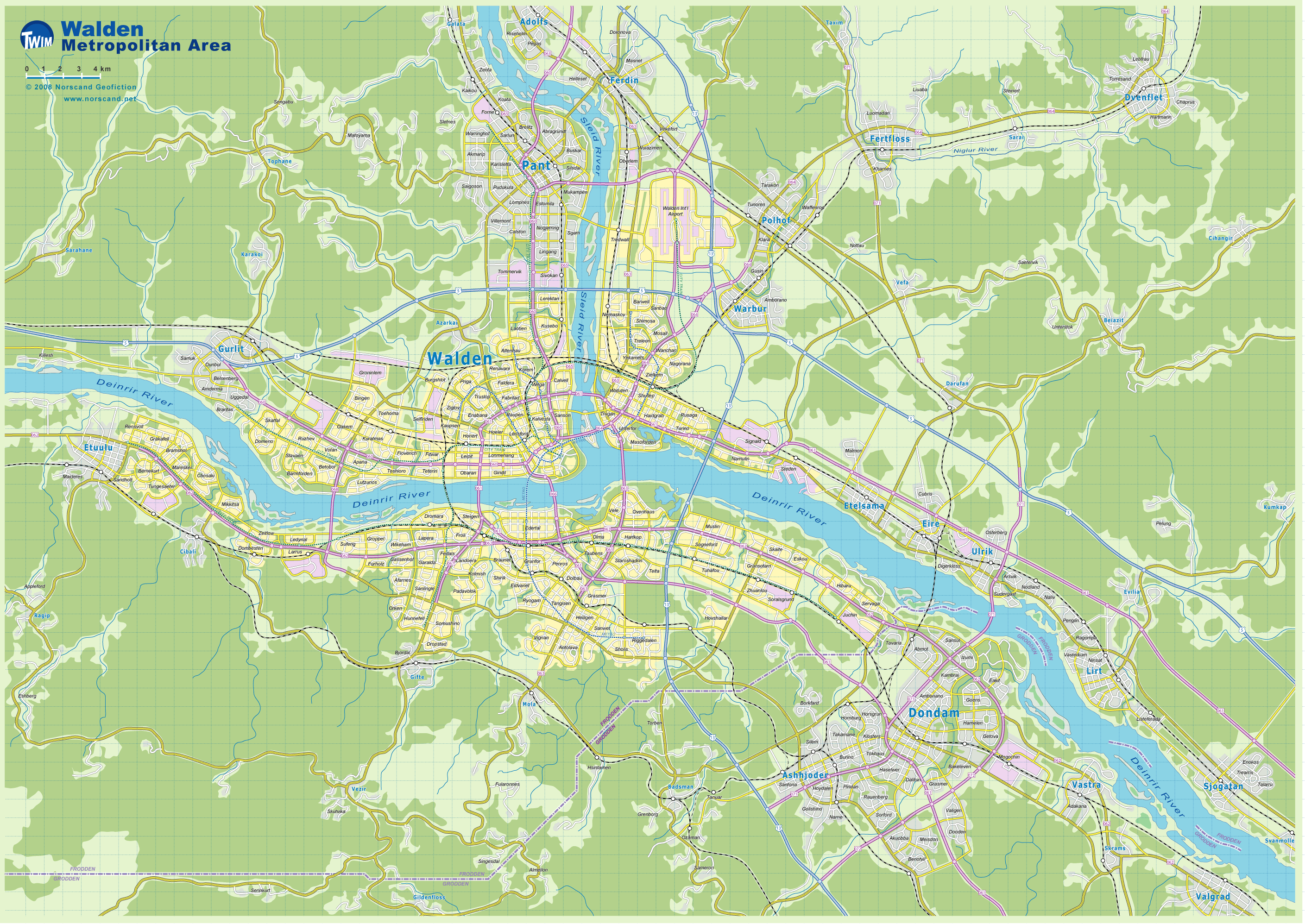
May, 21 Walden Metro Area map added
2008,
May, 10 Gramen metro area (east part) detailed street map added
2008,
May, 3 Map of Norscand railway passenger services added
2008,
April, 26 Gramen metro area (north part) detailed streetmap added
2008,
April, 20 Norscand Road Atlas Page 5 added
2008,
April, 12 Gramen metro area (west part) detailed streetmap added
2008,
April, 5 Gramen detailed streetmap added
2008,
March, 29 Grenlinn Area Rail Rapid Transitmap added
2008,
March, 22 Grenlinn Metro Area map is available in Scansey region
2008,
March, 16 Norscand Road Atlas Page 4 added
2008,
March, 9 Norscand Road Atlas Page 3 added, page 2 revised
2008,
February, 25 Norscand Road Atlas Page 2 added, page 1 revised
2008,
February, 23 Pentlan Area Rail Rapid Transit map added with bonus map of Pentlan rail service in UrbanRail site style.
2008,
February, 19 The second largest metro area in Norvag Region Pentlan City is available to view
2008,
February, 10 One more map added: Scoltroit metro area rail rapid transit in Garand
Region
2008,
February, 5 One more map added: Scodam
area rail rapid transit in Garand
Region
2008,
January, 30 New subproject was launched: Norscand
Road Atlas. It will contain 22 detailed
maps. Now the first page is accessible.
2008,
January, 27 Map
of Norscand passenger airlines has been added.
2008,
January, 26 Physical
map has been added.
2008,
January, 21 Norscand
Geofiction on the net
"Norscand Geofiction Maps" website was launched
on the net. Initially 15 maps of different places of imaginary country
Norscand are available to view. Maps are grouped into 3 categories such
as general (thematic maps concerning all the country), regional (reflecting
particular regions and cities) and transport maps (including public transit
and related). Welcome and enjoy!
|
